A Little Bit of Mount Graham History
By John Ratje
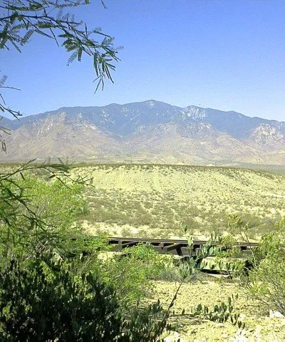
Local people refer to the entire mountain range southwest of Safford as Mt. Graham. The actual name "Pinaleño Mountains" comes from an Indian word meaning "many deer", or "deer mountain."1 The summit of the Pinaleño Mountains, Mount Graham (also known as High Peak), is at an elevation of 10,720 feet.
The mountain was named in 1846, when during the war with Mexico, the Army of the West, led by General Stephen Watts Kearney, came down the Gila River on its way to California [maneuvers during the U.S.-Mexican Wars]. Lt. William Emory, a topographer and scientist for the group, referred to the mountain in his journal and on the map of his trip as Mount Graham, for his friend and fellow Army officer James Duncan Graham.2 Lieutenant Colonel Graham was a senior officer in the Army Corps of Topographical Engineers.3 Graham County is named after Mt. Graham.
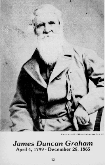
Namesake of Mount Graham
Mt. Graham is a marked contrast to the other peaks in the area. Most of the others are lava deposits; Graham blasted its way from below the surface of the earth and rose to an elevation of 10,713 feet above sea level. Unlike the lava based-mountains, which are either barren or foliated by low shrubs, Mt. Graham has a profusion of trees that date back to antiquity. Researchers from the University of Arizona (Tree Ring) Laboratory have discovered living trees that date back to 1257 and 1270 AD. Botanists say the Douglas firs have survived because the rocky cliffs of the mountains have served as a fire barrier for them. The scientists also found dead firs that dated as far back as 1102.4
While the Mt. Graham area has been inhabited more or less continually in the past, the Gila Valley can trace its recorded history back to the time of the Spanish Conquistadores. They passed through in the 1500s while searching for the Seven Cities of Cibola, fabled settlements where streets were supposedly paved with gold. Many of them stayed in Pueblo Viejo on the slopes of Mt. Graham, and treasure-hunters still turn up armor, weapons and equipment from that era.4
In the early 1880’s settlers came to the area in large numbers. These settlers found that the nearby mountains were a great benefit. Lumbering provided materials for building as well as employment for growing communities in the area. The settlers also found Mt. Graham to be a cool retreat from the hot desert. Summer homes were therefore, built around the sawmills so that families could be with the men who were working there.2
The first roads up the mountain were only wide enough for men to ride up on horseback. Portions were then improved to allow access by wagons, and then by larger vehicles to transport the lumber down from the mills. Through efforts of the government, an improved road was started in the 1920’s, and was completed as far as Arcadia by about 1927.2 This road was named Swift Trail after Thomas T. Swift, a Forest Supervisor with the Crook National Forest at that time. General Crook was involved with the Indian Wars in the late 1800’s. In 1953 the Crook National Forest came under the jurisdiction of the Coronado National Forest and the Safford Ranger District was established.
By the 1930’s the Civilian Conservation Corps, also known as the CCC, were in operation, providing employment for young men during the Depression. Men from all over the country came to Graham County to work in the numerous camps, several located on Mount Graham. Treasure Park and Columbine were used during the summer months, and Arcadia, Noon Creek and other sites were used during the winter months. Many of the improvements at campgrounds, as well as hiking trails, roads and other facilities now enjoyed by many visitors to Mount Graham, were built by the CCC personnel.2
Mount Graham provides today’s visitors a wealth of activity, from sight seeing to more strenuous activities such as hiking, rock climbing, and cross country skiing. There is something for all at this popular retreat. Trout fishing at Riggs Flat Lake is a popular summer pastime, and several of the year-round creeks offer the challenge of stream fishing. Big game (bear and deer) hunting is available, in season.2 The mountain is the home of the densest concentration of Black Bears in the Southwest.
The Graham County Chamber of Commerce and U.S. Forest Service can provide you with more information. The Columbine Visitors Information Center, operated by the U.S. Forest Service, also offers more information, including scrapbooks with pictures of the activities on Mt. Graham, including the old sawmill camps.
"Majestic Mount Graham" -- photograph by John Ratje
References:
- Arizona Place Names, Will C. Barnes, University of Arizona Press, Tucson, 1935
- Eastern Arizona Almanac, Author Unknown, Safford, Spring 1996.
- Who Named the Mountains, Coronado National Forest, 1991
- History, Legends and Tales – the Old West Highway, Where History Still Lives, Sam Lowe